
We use essential cookies for the proper functioning of the website and additional ones to make interaction with the site as convenient as possible. It helps us personalize your user experience as well as obtain analytical information to improve the service.
If you agree to accept all cookies, click "Accept all"; if not, click "Only essential". To learn more, view the Cookie Policy.
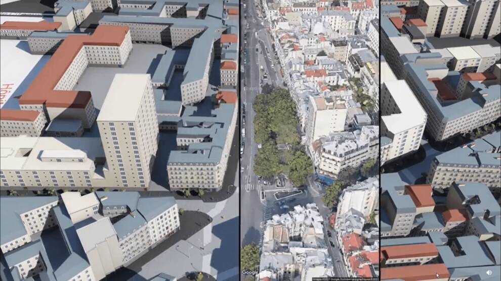
User showed how google maps turn into 3D cities
City models based on data from maps and open traffic information are generated by a Reddit user. In a recent work, he showed how this is done.
The use of artificial intelligence allows not only repeating real locations, but also populating it with people and traffic. In its work, Reddit uses open data and 3D models of cities from Google maps.
The algorithm used by the user was tested back in 2007. Its goal is to display a realistic simulation of city life. Artificial intelligence allows you to create a virtual prototype of a city location in just a few hours and "fill" it with movement.
The people who pop up on Reddit cities aren't just a random crowd. Each person has a well-thought-out system of behavior - motivation and socialization. Interacts with the environment.
In the first video, Reddit used the prototype of the Parisian street in which he once lived. First, I selected the desired area on the map, formed a location model with passers-by and traffic. The only element that was thought up was the fountain in the center of the boulevard.
For the second video, neighboring locations in Paris were used. The area was also highlighted, but then Reddit compared it to a real panorama.
The user has to create the appearance of buildings on his own. I paid attention to the details, so I recreated the silhouette of the streets almost unmistakably.
To develop such algorithms or shoot videos, you need to purchase the appropriate equipment. For example, in the section "PCs, laptops, tablets, office equipment".